Călimani National Park
24,041 hectares of unspoiled volcanic wilderness in the heart of Transylvania —
the highest volcanic peaks of the Carpathians, an ancient 10 km wide crater and the habitat of large carnivores
Source: Parcul Național Călimani
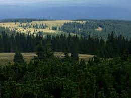
The highest volcanic massif of the Carpathians
Călimani National Park (Romanian: Parcul Național Călimani) is one of Romania's most valuable protected natural areas — lying at the very heart of the largest volcanic mountain range of the Carpathians.
The park covers 24,041 hectares and stretches across three counties (Mureș, Harghita and Suceava). Classified as IUCN category II, the national park was established in 1990 — its purpose is to safeguard the volcanic geological formations, the untouched forests and one of the richest flora and fauna in the Carpathians.
Several peaks of the massif rise above 2,000 metres above sea level: this is the home of Pietrosul Călimanilor (2100 m) — the highest volcanic peak in the entire Carpathian chain — together with Negoiul Unguresc (2081 m), Izvorul Călimanului Peak (2032 m) and Rețițișul (2021 m).
 The volcanic peaks of the Călimani Mountains · calimani.ro
Four special reserves within the park
Călimani National Park is not a uniform protection zone — within its territory lie several special reserves with different IUCN classifications, each safeguarding a different natural value: geological, botanical or habitat-related.
Twelve Apostles Memorial Park
IUCN III. — An andesite rock group at 1,760 m altitude, with anthropomorphic rock formations shaped by selective erosion.
Swiss stone pine reserve
IUCN I. — The Jnepeniș cu Pinus cembra Scientific Reserve protects the ancient stand of the Swiss stone pine (Pinus cembra) and dwarf mountain pine (Pinus mugo).
Iezer Lake (Bánffy Tarn)
IUCN IV. — A 322-hectare geological and habitat reserve, with a triangular alpine lake at 1,750 m at its centre — the jewel of the mountains.
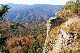
The ancient 10 km wide volcanic crater
At the heart of the massif lies a huge volcanic crater 10 kilometres in diameter — one of the largest such formations in the Carpathians. The crater ring is bordered by the park's highest peaks, and inside it stand secondary volcanic vents.
The crater rim is formed by Pietrosul Călimanilor (2100 m), Negoiul Unguresc (2081 m), Izvorul Călimanului Peak (2032 m), Rețițișul (2021 m), Bistricior Peak (2013 m) and Pietricelul (1993 m). To the north, the Neagra Șarului brook cuts through the crater rim.
Inside the crater stand several secondary volcanic vents. The most important is Negoiul Românesc (1889 m), where open-pit sulphur mining continued until 1997 — it remains one of the park's most painful environmental legacies: the summit has been scraped down to a yellowish-red colour, destroying the rare cave system as well.
The national park in pictures
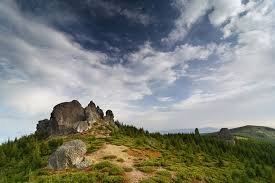
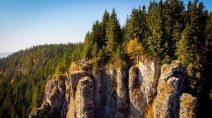
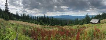
Photo sources: calimani.ro · visitharghita.com · greenharghita.ro · Salvamont Harghita
Botanical treasures and large carnivores
The national park offers refuge both to the rare plants of the mountain forests and to every characteristic large game animal of the Carpathians — from the brown bear and the wolf to the lynx.
Among the rarities of the flora are hoary ragwort (Senecio incanus), Carpathian Tozzia (Tozzia alpina subsp. carpathica), thrift (Armeria maritima) and the carpet-like stands of the Transylvanian alpine rose (Rhododendron kotschyi).
The park is home to the brown bear, wolf, lynx and European roe deer, as well as red deer. In the higher regions the golden eagle and the raven can also be spotted — the reason for its UNESCO biosphere status.
Before you set out
Permitted activities
- Hiking on the marked trails
- Mountain biking (on designated trails)
- Nature photography, birdwatching
- Camping only at designated sites
- Skiing (White Mountain, near Toplița)
Forbidden activities
- Lighting campfires in the park
- Disturbing plants, rocks and animals
- Loud noise, loud music
- Drone use without permit
- Leaving the marked trails is dangerous and forbidden
How to get there
- From Toplița: via the Borsec exit
- From Borsec: along DN15 towards Toplița
- From Suceava County: via Gura Haitii or Vatra Dornei
- Inner roads: 4×4 vehicles or on foot only
- GPS: 47.127° N, 25.168° E
Bear safety
- Active brown bear habitat
- Hike only in groups, by daylight
- Make your presence known (talking, music)
- Keep food in airtight containers
- Salvamont emergency: 0725 826 668
Responsible visiting in the protected area
Călimani National Park is one of Europe's most unspoiled volcanic landscapes — and so it is our responsibility not only to explore it, but also to preserve it for those who come after us. High-mountain ecosystems are very fragile: a trampled patch of rhododendron may need decades to regenerate.
Take with you what you brought, stay on the marked trails and respect the park's rules. Do not pick plants, do not disturb the wildlife — leave your memories only in your camera. Thank you!
Did you know?
Pietrosul Călimanilor (2100 m) is the highest volcanic peak in the entire Carpathian range. The neighbouring Negoiul Unguresc (2081 m) was named after Hungarian prime minister Pál Teleki in 1940, on the return of Northern Transylvania — hence the Hungarian-side name.
The massif consists of 12 calderas (extinct volcanic craters) in total — the largest of them is the main crater that contains Pietrosul Călimanilor, 10 km wide and 16 km long, one of the most impressive volcanic formations in the Carpathians.
The famous Maria Theresa Road — built in 1762 as a border patrol road between Hungary and Moldavia — crosses the park's alpine region and today serves as a hiking trail marked with a red dot.
The mineral water springs at the foot of the park — Toplița, Borsec, Bilbor — are direct legacies of post-volcanic activity, forming one of the richest mineral water regions of the Carpathians.